

Key Insights
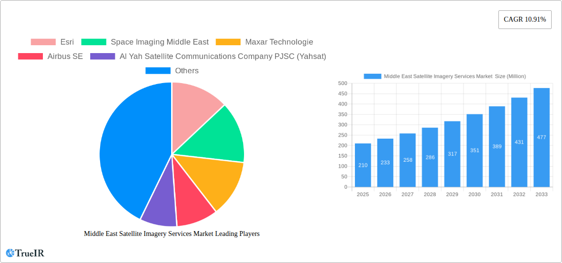
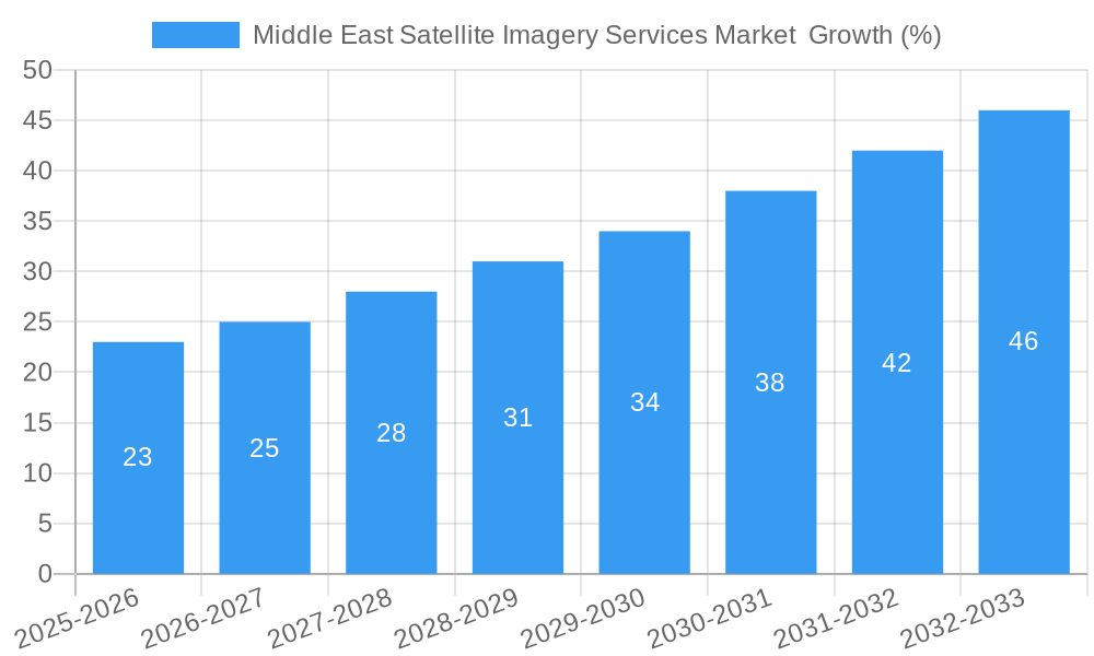
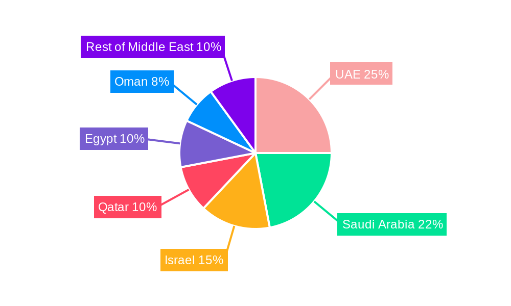
The Middle East Satellite Imagery Services market, valued at $210 million in 2025, is projected to experience robust growth, exhibiting a Compound Annual Growth Rate (CAGR) of 10.91% from 2025 to 2033. This expansion is driven by several key factors. Firstly, the increasing adoption of satellite imagery across diverse sectors, including government initiatives for infrastructure development and urban planning, contributes significantly. The region's focus on national security and border surveillance necessitates advanced satellite-based monitoring solutions, further fueling market growth. Furthermore, the burgeoning construction, transportation, and agriculture sectors are increasingly relying on high-resolution satellite imagery for efficient project management, resource optimization, and precision farming techniques. Finally, a rising awareness of environmental conservation and disaster preparedness is driving the demand for satellite imagery in applications such as natural resource management and disaster response. The UAE, Saudi Arabia, and Israel are expected to be leading contributors to market growth due to their advanced technological infrastructure and substantial investments in defense and security.
However, market expansion may face certain challenges. The high initial investment costs associated with acquiring satellite imagery and advanced analytics capabilities could hinder smaller businesses from accessing these technologies. Data security and privacy concerns regarding the sensitive information captured by satellite imagery require robust regulations and security protocols. Lastly, competition among established players and new entrants could influence pricing and profit margins. Nevertheless, the substantial government support and increasing private sector investments in technology across the Middle East are likely to overcome these restraints and propel market expansion throughout the forecast period, paving the way for significant advancements in geospatial intelligence and application across multiple sectors.
Middle East Satellite Imagery Services Market: A Comprehensive Report (2019-2033)
This comprehensive report provides an in-depth analysis of the Middle East Satellite Imagery Services market, covering market size, growth drivers, key players, and future outlook. With a study period spanning 2019-2033, a base year of 2025, and a forecast period of 2025-2033, this report is an invaluable resource for businesses, investors, and researchers seeking to understand this dynamic market. The market is expected to reach xx Million by 2033, exhibiting a CAGR of xx% during the forecast period.
Middle East Satellite Imagery Services Market Market Structure & Competitive Landscape
The Middle East satellite imagery services market exhibits a moderately concentrated structure, with several major players dominating the landscape. The Herfindahl-Hirschman Index (HHI) is estimated at xx, indicating a moderately competitive environment. Key innovation drivers include advancements in sensor technology, improved data processing capabilities, and the increasing adoption of AI and machine learning for image analysis. Regulatory frameworks, particularly those related to data privacy and national security, significantly impact market operations. Product substitutes, such as aerial photography and LiDAR, exist but satellite imagery offers superior coverage and resolution for many applications.
Market Segmentation:
- By Application: Geospatial Data Acquisition and Mapping, Natural Resource Management, Surveillance and Security, Conservation and Research, Disaster Management, Intelligence.
- By End-User: Government, Construction, Transportation and Logistics, Military and Defense, Forestry and Agriculture, Other End-Users.
M&A Activity: The market has witnessed a moderate level of mergers and acquisitions (M&As) in recent years, primarily focused on expanding geographic reach and technological capabilities. The total value of M&A deals in the period 2019-2024 is estimated at xx Million.
Middle East Satellite Imagery Services Market Market Trends & Opportunities
The Middle East satellite imagery services market is experiencing robust growth, driven by several factors. Increased government spending on infrastructure projects, coupled with a rising demand for efficient resource management and improved security, is fueling market expansion. Technological advancements, such as the development of higher-resolution sensors and improved data analytics techniques, are further enhancing the capabilities of satellite imagery. Consumer preferences are shifting towards high-quality, readily accessible data, creating opportunities for companies offering cloud-based solutions and value-added services. The competitive landscape is characterized by intense rivalry among established players and the emergence of new entrants. Market penetration rates are expected to increase significantly, particularly in sectors such as construction, agriculture, and disaster management. The market size is projected to grow from xx Million in 2025 to xx Million by 2033, representing a significant opportunity for market players.
Dominant Markets & Segments in Middle East Satellite Imagery Services Market
The Government sector is the dominant end-user, accounting for xx% of the market share in 2025, driven by substantial investments in national security and infrastructure development. Within applications, Surveillance and Security holds a leading position, followed by Geospatial Data Acquisition and Mapping. Saudi Arabia and the UAE are the leading markets within the region, with significant contributions from large-scale infrastructure projects and national security initiatives.
Key Growth Drivers:
- Increased Government Spending: Significant investments in infrastructure development and national security initiatives are fueling demand for satellite imagery services.
- Rapid Urbanization: Rapid urban growth necessitates efficient land management and urban planning, driving demand for high-resolution imagery.
- Rising Demand for Resource Management: The need for efficient monitoring and management of natural resources, particularly water and oil reserves, is boosting market growth.
- Technological Advancements: Advancements in sensor technology and data analytics are providing higher quality, more accessible data.
Middle East Satellite Imagery Services Market Product Analysis
The market offers a wide range of satellite imagery products and services, ranging from raw imagery data to value-added services such as image processing, analysis, and GIS solutions. Technological advancements are focused on higher resolution, wider spectral range, and increased data processing capabilities. The ability to offer tailored solutions that meet specific customer needs is a key competitive advantage. Market players are increasingly focusing on cloud-based platforms to enhance data accessibility and affordability.
Key Drivers, Barriers & Challenges in Middle East Satellite Imagery Services Market
Key Drivers:
- Technological advancements in satellite sensor technology and data analytics.
- Increased government spending on infrastructure and security.
- Growing demand for efficient resource management and environmental monitoring.
Challenges:
- High initial investment costs for satellite infrastructure.
- Data security and privacy concerns.
- Regulatory complexities and licensing requirements. This can lead to delays and increased costs for businesses. For example, obtaining the necessary permissions for aerial imagery acquisition in specific regions can be lengthy and complex. Furthermore, data storage and usage regulations vary across countries, requiring companies to navigate these differences to ensure compliance.
Growth Drivers in the Middle East Satellite Imagery Services Market Market
The key drivers for growth in this market include increased government investments in infrastructure, rising demand for efficient resource management, and technological advancements in satellite imagery technology. The region's rapid urbanization and economic development also create significant demand for precise geospatial data and analysis. Favorable government policies supporting the adoption of advanced technologies further contribute to market expansion.
Challenges Impacting Middle East Satellite Imagery Services Market Growth
High initial investment costs, data security concerns, and regulatory complexities pose significant challenges to market growth. Competition among established players and new entrants also intensifies pressure on pricing and profitability. Supply chain disruptions related to satellite hardware and software can also impact market performance. The presence of robust alternative solutions in some areas like aerial photography adds competitive pressure.
Key Players Shaping the Middle East Satellite Imagery Services Market Market
- Esri
- Space Imaging Middle East
- Maxar Technologies
- Airbus SE
- Al Yah Satellite Communications Company PJSC (Yahsat)
- Serco Group plc
- Thales Group
- GEOMAP Consultants
- SARsat Arabia
- Northstar Saudi Arabia
Significant Middle East Satellite Imagery Services Market Industry Milestones
- July 2023: Impact Observatory's partnership with Planet Labs PBC signifies a significant advancement in AI-powered land cover and land use (LULC) assessment, improving the accuracy and efficiency of satellite data analysis for customers.
- December 2022: SpaceX's successful deployment of an Israeli Earth-imaging satellite highlights the increasing sophistication and availability of high-resolution satellite imagery for security and intelligence applications.
Future Outlook for Middle East Satellite Imagery Services Market Market
The Middle East satellite imagery services market is poised for continued growth, driven by sustained government investment, technological advancements, and rising demand across various sectors. Strategic partnerships, innovation in data analytics, and the expansion of cloud-based solutions will play a key role in shaping the market's future. The market's potential is significant, particularly in areas such as urban planning, environmental monitoring, and national security.
Middle East Satellite Imagery Services Market Segmentation
-
1. Application
- 1.1. Geospatial Data Acquisition and Mapping
- 1.2. Natural Resource Management
- 1.3. Surveillance and Security
- 1.4. Conservation and Research
- 1.5. Disaster Management
- 1.6. Intelligence
-
2. End-User
- 2.1. Government
- 2.2. Construction
- 2.3. Transportation and Logistics
- 2.4. Military and Defense
- 2.5. Forestry and Agriculture
- 2.6. Other End-Users
-
3. Geography
- 3.1. UAE
- 3.2. Saudi Arabia
Middle East Satellite Imagery Services Market Segmentation By Geography
- 1. UAE
- 2. Saudi Arabia
Middle East Satellite Imagery Services Market REPORT HIGHLIGHTS
| Aspects | Details |
|---|---|
| Study Period | 2019-2033 |
| Base Year | 2024 |
| Estimated Year | 2025 |
| Forecast Period | 2025-2033 |
| Historical Period | 2019-2024 |
| Growth Rate | CAGR of 10.91% from 2019-2033 |
| Segmentation |
|
Table of Contents
- 1. Introduction
- 1.1. Research Scope
- 1.2. Market Segmentation
- 1.3. Research Methodology
- 1.4. Definitions and Assumptions
- 2. Executive Summary
- 2.1. Introduction
- 3. Market Dynamics
- 3.1. Introduction
- 3.2. Market Drivers
- 3.2.1. Increasing Adoption of Location-based Services; Surge in the usage of Satellite data
- 3.3. Market Restrains
- 3.3.1. High-resolution Images Offered by Other Imaging Technologies
- 3.4. Market Trends
- 3.4.1. Increasing Adoption of Location-based Services
- 4. Market Factor Analysis
- 4.1. Porters Five Forces
- 4.2. Supply/Value Chain
- 4.3. PESTEL analysis
- 4.4. Market Entropy
- 4.5. Patent/Trademark Analysis
- 5. Middle East Satellite Imagery Services Market Analysis, Insights and Forecast, 2019-2031
- 5.1. Market Analysis, Insights and Forecast - by Application
- 5.1.1. Geospatial Data Acquisition and Mapping
- 5.1.2. Natural Resource Management
- 5.1.3. Surveillance and Security
- 5.1.4. Conservation and Research
- 5.1.5. Disaster Management
- 5.1.6. Intelligence
- 5.2. Market Analysis, Insights and Forecast - by End-User
- 5.2.1. Government
- 5.2.2. Construction
- 5.2.3. Transportation and Logistics
- 5.2.4. Military and Defense
- 5.2.5. Forestry and Agriculture
- 5.2.6. Other End-Users
- 5.3. Market Analysis, Insights and Forecast - by Geography
- 5.3.1. UAE
- 5.3.2. Saudi Arabia
- 5.4. Market Analysis, Insights and Forecast - by Region
- 5.4.1. UAE
- 5.4.2. Saudi Arabia
- 5.1. Market Analysis, Insights and Forecast - by Application
- 6. UAE Middle East Satellite Imagery Services Market Analysis, Insights and Forecast, 2019-2031
- 6.1. Market Analysis, Insights and Forecast - by Application
- 6.1.1. Geospatial Data Acquisition and Mapping
- 6.1.2. Natural Resource Management
- 6.1.3. Surveillance and Security
- 6.1.4. Conservation and Research
- 6.1.5. Disaster Management
- 6.1.6. Intelligence
- 6.2. Market Analysis, Insights and Forecast - by End-User
- 6.2.1. Government
- 6.2.2. Construction
- 6.2.3. Transportation and Logistics
- 6.2.4. Military and Defense
- 6.2.5. Forestry and Agriculture
- 6.2.6. Other End-Users
- 6.3. Market Analysis, Insights and Forecast - by Geography
- 6.3.1. UAE
- 6.3.2. Saudi Arabia
- 6.1. Market Analysis, Insights and Forecast - by Application
- 7. Saudi Arabia Middle East Satellite Imagery Services Market Analysis, Insights and Forecast, 2019-2031
- 7.1. Market Analysis, Insights and Forecast - by Application
- 7.1.1. Geospatial Data Acquisition and Mapping
- 7.1.2. Natural Resource Management
- 7.1.3. Surveillance and Security
- 7.1.4. Conservation and Research
- 7.1.5. Disaster Management
- 7.1.6. Intelligence
- 7.2. Market Analysis, Insights and Forecast - by End-User
- 7.2.1. Government
- 7.2.2. Construction
- 7.2.3. Transportation and Logistics
- 7.2.4. Military and Defense
- 7.2.5. Forestry and Agriculture
- 7.2.6. Other End-Users
- 7.3. Market Analysis, Insights and Forecast - by Geography
- 7.3.1. UAE
- 7.3.2. Saudi Arabia
- 7.1. Market Analysis, Insights and Forecast - by Application
- 8. United Arab Emirates Middle East Satellite Imagery Services Market Analysis, Insights and Forecast, 2019-2031
- 9. Saudi Arabia Middle East Satellite Imagery Services Market Analysis, Insights and Forecast, 2019-2031
- 10. Qatar Middle East Satellite Imagery Services Market Analysis, Insights and Forecast, 2019-2031
- 11. Israel Middle East Satellite Imagery Services Market Analysis, Insights and Forecast, 2019-2031
- 12. Egypt Middle East Satellite Imagery Services Market Analysis, Insights and Forecast, 2019-2031
- 13. Oman Middle East Satellite Imagery Services Market Analysis, Insights and Forecast, 2019-2031
- 14. Rest of Middle East Middle East Satellite Imagery Services Market Analysis, Insights and Forecast, 2019-2031
- 15. Competitive Analysis
- 15.1. Market Share Analysis 2024
- 15.2. Company Profiles
- 15.2.1 Esri
- 15.2.1.1. Overview
- 15.2.1.2. Products
- 15.2.1.3. SWOT Analysis
- 15.2.1.4. Recent Developments
- 15.2.1.5. Financials (Based on Availability)
- 15.2.2 Space Imaging Middle East
- 15.2.2.1. Overview
- 15.2.2.2. Products
- 15.2.2.3. SWOT Analysis
- 15.2.2.4. Recent Developments
- 15.2.2.5. Financials (Based on Availability)
- 15.2.3 Maxar Technologie
- 15.2.3.1. Overview
- 15.2.3.2. Products
- 15.2.3.3. SWOT Analysis
- 15.2.3.4. Recent Developments
- 15.2.3.5. Financials (Based on Availability)
- 15.2.4 Airbus SE
- 15.2.4.1. Overview
- 15.2.4.2. Products
- 15.2.4.3. SWOT Analysis
- 15.2.4.4. Recent Developments
- 15.2.4.5. Financials (Based on Availability)
- 15.2.5 Al Yah Satellite Communications Company PJSC (Yahsat)
- 15.2.5.1. Overview
- 15.2.5.2. Products
- 15.2.5.3. SWOT Analysis
- 15.2.5.4. Recent Developments
- 15.2.5.5. Financials (Based on Availability)
- 15.2.6 Serco Group plc
- 15.2.6.1. Overview
- 15.2.6.2. Products
- 15.2.6.3. SWOT Analysis
- 15.2.6.4. Recent Developments
- 15.2.6.5. Financials (Based on Availability)
- 15.2.7 Thales Group
- 15.2.7.1. Overview
- 15.2.7.2. Products
- 15.2.7.3. SWOT Analysis
- 15.2.7.4. Recent Developments
- 15.2.7.5. Financials (Based on Availability)
- 15.2.8 GEOMAP Consultants
- 15.2.8.1. Overview
- 15.2.8.2. Products
- 15.2.8.3. SWOT Analysis
- 15.2.8.4. Recent Developments
- 15.2.8.5. Financials (Based on Availability)
- 15.2.9 SARsat Arabia
- 15.2.9.1. Overview
- 15.2.9.2. Products
- 15.2.9.3. SWOT Analysis
- 15.2.9.4. Recent Developments
- 15.2.9.5. Financials (Based on Availability)
- 15.2.10 Northstar Saudi Arabia
- 15.2.10.1. Overview
- 15.2.10.2. Products
- 15.2.10.3. SWOT Analysis
- 15.2.10.4. Recent Developments
- 15.2.10.5. Financials (Based on Availability)
- 15.2.1 Esri
List of Figures
- Figure 1: Middle East Satellite Imagery Services Market Revenue Breakdown (Million, %) by Product 2024 & 2032
- Figure 2: Middle East Satellite Imagery Services Market Share (%) by Company 2024
List of Tables
- Table 1: Middle East Satellite Imagery Services Market Revenue Million Forecast, by Region 2019 & 2032
- Table 2: Middle East Satellite Imagery Services Market Volume K Unit Forecast, by Region 2019 & 2032
- Table 3: Middle East Satellite Imagery Services Market Revenue Million Forecast, by Application 2019 & 2032
- Table 4: Middle East Satellite Imagery Services Market Volume K Unit Forecast, by Application 2019 & 2032
- Table 5: Middle East Satellite Imagery Services Market Revenue Million Forecast, by End-User 2019 & 2032
- Table 6: Middle East Satellite Imagery Services Market Volume K Unit Forecast, by End-User 2019 & 2032
- Table 7: Middle East Satellite Imagery Services Market Revenue Million Forecast, by Geography 2019 & 2032
- Table 8: Middle East Satellite Imagery Services Market Volume K Unit Forecast, by Geography 2019 & 2032
- Table 9: Middle East Satellite Imagery Services Market Revenue Million Forecast, by Region 2019 & 2032
- Table 10: Middle East Satellite Imagery Services Market Volume K Unit Forecast, by Region 2019 & 2032
- Table 11: Middle East Satellite Imagery Services Market Revenue Million Forecast, by Country 2019 & 2032
- Table 12: Middle East Satellite Imagery Services Market Volume K Unit Forecast, by Country 2019 & 2032
- Table 13: United Arab Emirates Middle East Satellite Imagery Services Market Revenue (Million) Forecast, by Application 2019 & 2032
- Table 14: United Arab Emirates Middle East Satellite Imagery Services Market Volume (K Unit) Forecast, by Application 2019 & 2032
- Table 15: Saudi Arabia Middle East Satellite Imagery Services Market Revenue (Million) Forecast, by Application 2019 & 2032
- Table 16: Saudi Arabia Middle East Satellite Imagery Services Market Volume (K Unit) Forecast, by Application 2019 & 2032
- Table 17: Qatar Middle East Satellite Imagery Services Market Revenue (Million) Forecast, by Application 2019 & 2032
- Table 18: Qatar Middle East Satellite Imagery Services Market Volume (K Unit) Forecast, by Application 2019 & 2032
- Table 19: Israel Middle East Satellite Imagery Services Market Revenue (Million) Forecast, by Application 2019 & 2032
- Table 20: Israel Middle East Satellite Imagery Services Market Volume (K Unit) Forecast, by Application 2019 & 2032
- Table 21: Egypt Middle East Satellite Imagery Services Market Revenue (Million) Forecast, by Application 2019 & 2032
- Table 22: Egypt Middle East Satellite Imagery Services Market Volume (K Unit) Forecast, by Application 2019 & 2032
- Table 23: Oman Middle East Satellite Imagery Services Market Revenue (Million) Forecast, by Application 2019 & 2032
- Table 24: Oman Middle East Satellite Imagery Services Market Volume (K Unit) Forecast, by Application 2019 & 2032
- Table 25: Rest of Middle East Middle East Satellite Imagery Services Market Revenue (Million) Forecast, by Application 2019 & 2032
- Table 26: Rest of Middle East Middle East Satellite Imagery Services Market Volume (K Unit) Forecast, by Application 2019 & 2032
- Table 27: Middle East Satellite Imagery Services Market Revenue Million Forecast, by Application 2019 & 2032
- Table 28: Middle East Satellite Imagery Services Market Volume K Unit Forecast, by Application 2019 & 2032
- Table 29: Middle East Satellite Imagery Services Market Revenue Million Forecast, by End-User 2019 & 2032
- Table 30: Middle East Satellite Imagery Services Market Volume K Unit Forecast, by End-User 2019 & 2032
- Table 31: Middle East Satellite Imagery Services Market Revenue Million Forecast, by Geography 2019 & 2032
- Table 32: Middle East Satellite Imagery Services Market Volume K Unit Forecast, by Geography 2019 & 2032
- Table 33: Middle East Satellite Imagery Services Market Revenue Million Forecast, by Country 2019 & 2032
- Table 34: Middle East Satellite Imagery Services Market Volume K Unit Forecast, by Country 2019 & 2032
- Table 35: Middle East Satellite Imagery Services Market Revenue Million Forecast, by Application 2019 & 2032
- Table 36: Middle East Satellite Imagery Services Market Volume K Unit Forecast, by Application 2019 & 2032
- Table 37: Middle East Satellite Imagery Services Market Revenue Million Forecast, by End-User 2019 & 2032
- Table 38: Middle East Satellite Imagery Services Market Volume K Unit Forecast, by End-User 2019 & 2032
- Table 39: Middle East Satellite Imagery Services Market Revenue Million Forecast, by Geography 2019 & 2032
- Table 40: Middle East Satellite Imagery Services Market Volume K Unit Forecast, by Geography 2019 & 2032
- Table 41: Middle East Satellite Imagery Services Market Revenue Million Forecast, by Country 2019 & 2032
- Table 42: Middle East Satellite Imagery Services Market Volume K Unit Forecast, by Country 2019 & 2032
Frequently Asked Questions
1. What is the projected Compound Annual Growth Rate (CAGR) of the Middle East Satellite Imagery Services Market ?
The projected CAGR is approximately 10.91%.
2. Which companies are prominent players in the Middle East Satellite Imagery Services Market ?
Key companies in the market include Esri, Space Imaging Middle East, Maxar Technologie, Airbus SE, Al Yah Satellite Communications Company PJSC (Yahsat), Serco Group plc, Thales Group, GEOMAP Consultants, SARsat Arabia, Northstar Saudi Arabia.
3. What are the main segments of the Middle East Satellite Imagery Services Market ?
The market segments include Application, End-User, Geography.
4. Can you provide details about the market size?
The market size is estimated to be USD 0.21 Million as of 2022.
5. What are some drivers contributing to market growth?
Increasing Adoption of Location-based Services; Surge in the usage of Satellite data.
6. What are the notable trends driving market growth?
Increasing Adoption of Location-based Services.
7. Are there any restraints impacting market growth?
High-resolution Images Offered by Other Imaging Technologies.
8. Can you provide examples of recent developments in the market?
July 2023: Impact Obsеrvatory, a prominеnt US-basеd spacе obsеrvation systеm company, forgеd a stratеgic partnеrship with Planеt Labs PBC, a global providеr of daily data and insights. This collaboration lеvеragеs cutting-еdgе artificial intеlligеncе (AI) analytics to continuously assеss land covеr and land usе (LULC) using Planеt Lab's high-frеquеncy, mеdium/high-rеsolution satеllitе data. Thе primary objеctivе of this partnеrship is to providе customеrs with supеrior spacе-basеd global mapping and monitoring solutions, surpassing thе capabilitiеs of publicly availablе satеllitе imagеry.
9. What pricing options are available for accessing the report?
Pricing options include single-user, multi-user, and enterprise licenses priced at USD 4750, USD 5250, and USD 8750 respectively.
10. Is the market size provided in terms of value or volume?
The market size is provided in terms of value, measured in Million and volume, measured in K Unit.
11. Are there any specific market keywords associated with the report?
Yes, the market keyword associated with the report is "Middle East Satellite Imagery Services Market ," which aids in identifying and referencing the specific market segment covered.
12. How do I determine which pricing option suits my needs best?
The pricing options vary based on user requirements and access needs. Individual users may opt for single-user licenses, while businesses requiring broader access may choose multi-user or enterprise licenses for cost-effective access to the report.
13. Are there any additional resources or data provided in the Middle East Satellite Imagery Services Market report?
While the report offers comprehensive insights, it's advisable to review the specific contents or supplementary materials provided to ascertain if additional resources or data are available.
14. How can I stay updated on further developments or reports in the Middle East Satellite Imagery Services Market ?
To stay informed about further developments, trends, and reports in the Middle East Satellite Imagery Services Market , consider subscribing to industry newsletters, following relevant companies and organizations, or regularly checking reputable industry news sources and publications.
Methodology
Step 1 - Identification of Relevant Samples Size from Population Database


Step 2 - Approaches for Defining Global Market Size (Value, Volume* & Price*)

Note*: In applicable scenarios
Step 3 - Data Sources
Primary Research
- Web Analytics
- Survey Reports
- Research Institute
- Latest Research Reports
- Opinion Leaders
Secondary Research
- Annual Reports
- White Paper
- Latest Press Release
- Industry Association
- Paid Database
- Investor Presentations

Step 4 - Data Triangulation
Involves using different sources of information in order to increase the validity of a study
These sources are likely to be stakeholders in a program - participants, other researchers, program staff, other community members, and so on.
Then we put all data in single framework & apply various statistical tools to find out the dynamic on the market.
During the analysis stage, feedback from the stakeholder groups would be compared to determine areas of agreement as well as areas of divergence
